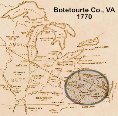
John Kitts was in Botetourt/Fincastle County, Virginia as early as 1769/1770. The map above depicts both Augusta and Botetourte County borders in 1770.
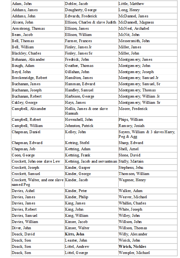
John Kitts & Nicholas Wyrick in 1771, Tithables (Taxes), Botetourte Co., VA
( The Early Adventurers on the Western Waters, Volume III, Part 1, pp 253-255, by Mary B. Kegley.)
Immediately above is a List of Tithables taken in by Walter Crockett from William Sayers to the Head of Holston River 1771.
In 1772, John Kitts & Nicholas Wyrick are listed in Tithables (Taxes), Botetourte Co., VA as listed by Walter Crockett.
No property deed has been found in John Kitts name. However, references have been made in other deeds to 150 acres John Kitts owned on Doaks Mill Creek.
These references are listed below for an attempt at locating the Kitts property:
September 23, 1782
Montgomery and Fincastle Counties
Entry Book A 1773-1777; 1780-1783, page 144
(Transcribed from a photocopy of the original entry found at the Montgomery Co. Courthouse in Christiansburg, VA)
Lawrence Hatharine assignee of John Kitts by virtue of a Commissioner Certificate enters 150 acres on Doaks Mill Creek a branch of Reed Creek adjoining a survey made under the Loyal Company Grant to include the improvement.
November 19, 1783
81 acres surveyed in Montgomery listed on November 19, 1783
Montgomery County Record of Plats, Book B, Page 46.
(Copied from the original original entry found at the Montgomery Co. Courthouse in Christiansburg, VA)
"Surveyed for Laurence Kettering 81 acres of land by virtue of an entry made on a certificate to him …dated September 25, 1782" It is unclear why he (Lawrence Hatharine/Kettering) only had 81 of the 150 acres surveyed. Here is the description."…81 acres…lying on Doaks Mill Creek a branch of Reed Creek a branch of the New River in the County of Montgomery adjoining a survey made under the Loyal Companies grant beginning at a chesnut on a ridge a corner to the above mentioned survey. Thence S 58 degrees W 78 poles to a white oak and black oak, thence S 25 W 96 poles to a red oak on a high ridge, thence S 40 ½ E 15 C crossing said mill creek to a large white oak on a ridge S 82 E 48…to between a red oak and white oak, thence N 13 ½ E 35…to a maple N 75 W 7…to 2 white oaks a corner also to the above survey, thence the courses of said survey to the beginning viz N 59 W 107…to white oak and sugar tree on a hill, thence the said ___ N 17 E 165 poles to the beginning.
Nov. 19th, 1783. David McGavock, Wm Preston"
81 acres registered in Richmond June 24, 1785
(Transcribed from a copy of the microfilm of the original entry found the LVA Homepage)
June 24, 1785
Lawrence Kittring
81 acres
Montgomery. Patrick Henry Esquire Governor of the Commonwealth of Virginia
To all to whom these presents shall come, greeting: Know ye that by virtue of a part of a certificate in right of settlement given by the commissioners of or adjusting the titles unpatented lands in the District of Washington and Montgomery and in consideration of the amount composition of ten shillings sterling paid by Laurence Kittring into the treasury of this Commonwealth there is granted by the said Commonwealth, unto the said Lawrence Kittring a certain tract or parcel of land, containing eighty one acres by survey nearing date the nineteenth day of November one thousand seven hundred and eighty two lying and being in the County of Montgomery on Doaks Mill Creek a Branch of Reed Creek a Branch of New River adjoining a survey made under the Loyal Companies Grant . Bounded as followeth, to wit,
Beginning at a chestnut on a ridge a corner to the above mentioned survey thence to wit fifty eight degrees west seventy eight pole to a white oak and black oak thence south twenty five degrees West ninety six poles to a red oak on a high ridge thence south forty and a half degrees East one hundred and fifty six poles crossing said Mill Creek to a large white oak on a ridge South eighty two degrees East forty eight poles between a red oak and white oak thence north thirteen and a half degrees east thirty five poles to an apple North seventy five degrees West seven poles to two white oaks a corner also the the above survey Thence the course of said survey North fifty nine degrees West one hundred and seven poles to a white oak and sugar tree on the side of a hill thence North seventeen degrees East one hundred and sixty five poles to the beginning with its appurtenances;
To have and to hold the said tract or parcel of land with its appurtenances, to the said Laurence Kittring and his heirs forever . In witness whereof, the said Patrick Henry Esquire Governor of the Commonwealth of Virginia hath hereunto set his hand and caused the lesser seal of the said commonwealth to be affixed, at Richmond, on the twenty fourth day of June in the year of our Lord one thousand seven hundred and eighty five and of the commonwealth the ninth. P. Henry
Another reference to John Kitts property:
November 6, 1782
This entry made in Montgomery County November 06, 1782
"William Davies, military warrant 60 acres, and 50 acres on military warrant assigned by Mary McCown, enters 110 acres on Holston on Crabtree draft above Buchanan’s line and to include Kitts improvements."
This entry found at the Montgomery County Courthouse
Muster Roll 1776-1900, page 40
"I certify that the bearer hereof, William Davies, is entitled to two hundred acres of land for his service as a sergeant in a Company of Rangers under my command disbanded in May 1759 according to his Majesty's Proclamation of the 7th of Oct. 1763. Given under my hand this 1st day of March 1774.
Wm. Preston"
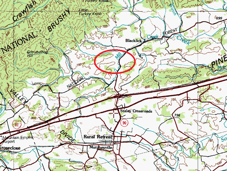
Approximate Location of John Kitts Virginia property based on Mary B. Kegley's "A Settlement Map of Wythe County, Virginia" found on page 31 of Spenser David Slough's Germans on the Western Waters: Artisans, Material Culture, and Hybridity in Virginia's Backcountry, 1780-1830.
